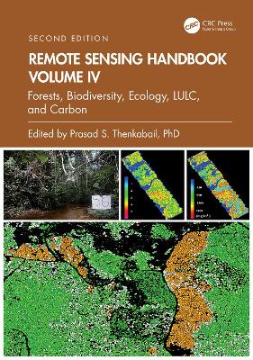
Remote Sensing Handbook, Volume IV
 portes grátis
Remote Sensing Handbook, Volume IV
Forests, Biodiversity, Ecology, LULC, and Carbon
Thenkabail, Prasad S.
Taylor & Francis Ltd
11/2024
502
Dura
9781032891033
Pré-lançamento - envio 15 a 20 dias após a sua edição
Descrição não disponível.
Part I: Forests. 1. Characterizing Tropical Forests with Multispectral Imagery. 2. Remote Sensing of Forests from Lidar and Radar. 3. Forest Biophysical and Biochemical Properties from Hyperspectral and LiDAR Remote Sensing. 4. Optical Remote Sensing of Tree and Stand Heights. Part II: Biodiversity. 5. Biodiversity of the World: A Study from Space. 6. Multi-scale Habitat Mapping and Monitoring using Satellite Data and Advanced Image Analysis Techniques. Part III: Ecology. 7. Ecological Characterization of Vegetation Using Multi-Sensor Remote Sensing in the Solar Reflective Spectrum. Part IV: Land Use/Land Cover. 8. Land Cover Change Detection. 9. Land Use and Land Cover Mapping and Monitoring wirh Radar Remote Sensing. V: Carbon. 10. Global Carbon Budgets and the Role of Remote Sensing. 11. Above-ground Terrestrial Biomass and Carbon Stock Estimations from Multi-sensor Remote Sensing. Part VI: Summary and Synthesis of Volume IV. 12. Remote Sensing Handbook, Volume IV: Forests, Biodiversity, Ecology, LULC and Carbon.
Este título pertence ao(s) assunto(s) indicados(s). Para ver outros títulos clique no assunto desejado.
Satellite, Global Navigation Satellite Systems, Big Data, Calibration;Optical, Radar, Lidar, Microwave, Hyperspectral, UAV;Crowdsourcing, Cloud Computing;Google Earth, Geospatial Data, Geoprocessing, Data Mining;Vegetation, Agriculture, Water Security, Food Security;Droughts, Disasters, Floods, Natural Resources

