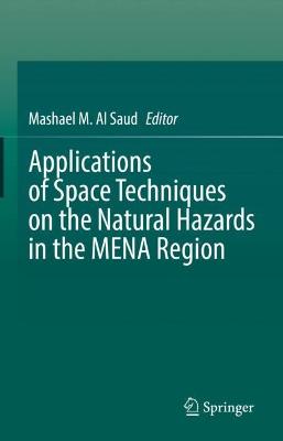
Applications of Space Techniques on the Natural Hazards in the MENA Region
 portes grátis
Applications of Space Techniques on the Natural Hazards in the MENA Region
Al Saud, Mashael M.
Springer Nature Switzerland AG
04/2022
635
Dura
Inglês
9783030888732
15 a 20 dias
1245
Descrição não disponível.
Part I: Introduction.- Chapter 1: Space Techniques and Earth Observation.- Chapter 2: Natural Hazards in the MENA Region.- Part II: Applications of Space Techniques for the MENA Region.- Chapter 3: Open Data and Tools for Multispectral Satellite Analysis of Desert Sand Dunes Migration: Case Studies in the MENA Region.- Chapter 4: How Severe is Water Stress in the MENA Region? Insights from GRACE and GRACE-FO Satellites and Global Hydrological Modeling.- Chapter 5: The Application of Remote Sensing on the Studies of Mean Sea Level Rise in the Arabian Gulf.- Chapter 6: Assessment of Vulnerability, Risk, and Adaptation of MENA Region to SLR by Remote Sensing and GIS.- Part III: Case Studies: Space techniques and Natural Hazards in the MENA Region.- Chapter 7: Use of satellite images and GIS for the assessment of natural hazards in Western Saudi Arabia.- Chapter 8: Remote Sensing and GIS application for Natural Hazards Assessment of the Mauritanian coastal zone.- Chapter 9: Remote sensing studies on monitoring natural hazards over cultural heritage sites in Cyprus.- Chapter 10: Flooding hazard assessment considering climate change in the coastal areas of Algeria based on a remote sensing and GIS data base.- Chapter 11: Geographical information systems (GIS) and multi-criteria analysis approach for flood risk mapping: case of Kasserine region, Tunisia.- Chapter 12: Applications of remote sensing techniques in earthquake and flood risk assessment in the Cyrenaica region, Al Jabal Al Akhdar area, NE Libya.- Integrated Methodology for Urban Flood Risk Mapping at the Microscale in Ungauged Regions: A Case Study of Hurghada, Egypt.- Chapter 14: Application of Remote Sensing and Geographic Information System Techniques to Flood and Rainwater Harvesting: Case Study of Sennar, Sudan.- Chapter 15: Drought Assessment Using GIS and Remote Sensing in Jordan.- Chapter 16: Using Remote Sensing Techniques for Identifying the Environmental and QuantitativeIndices of Drought in Tihama, Yemen.- Chapter 17: Assessment of drought impact on agricultural production using remote sensing and machine learning techniques in Kairouan prefecture, Tunisia.- Chapter 18: Quantitative assessment of land sensitivity to desertification in Central Sudan: An application of remote sensing-based MEDALUS Model.- Chapter 19: Selected benchmark for landslides susceptibility assessments in Northern Morocco.- Chapter 20: A Geophysical and Remote Sensing-based Approach for Monitoring Land Subsidence in Saudi Arabia.- Chapter 21: Landslide Susceptibility Map Production of Aden Peninsula - South West of Yemen.- Chapter 22: The use of Earth Observation data in wildfire fire risk management: a case study from Lebanon.- Chapter 23: Avalanche hazards with mitigation in Turkey and qualitative risk assessment for snow avalanches in Ayder (Rize, NE Turkey) using combination of GIS, remote sensing techniques and field studies.- Chapter 24: Space techniques to recognize seismological and geomorphological features in Libya.- Chapter 25: Seismological and remote sensing studies in the Dead Sea zone, Jordan 1987-2021.- Chapter 26: Study of soil erosion risks using remote sensing and in Ouergha River watershed.
Este título pertence ao(s) assunto(s) indicados(s). Para ver outros títulos clique no assunto desejado.
Space observation techniques;Natural hazards in the MENA region;Climate Change Mitigation;Natural risk prediction;Satellite images to discover Earth's processes;Natural threats to the socio-economoc sectors;Monitoring and environmental analysis
Part I: Introduction.- Chapter 1: Space Techniques and Earth Observation.- Chapter 2: Natural Hazards in the MENA Region.- Part II: Applications of Space Techniques for the MENA Region.- Chapter 3: Open Data and Tools for Multispectral Satellite Analysis of Desert Sand Dunes Migration: Case Studies in the MENA Region.- Chapter 4: How Severe is Water Stress in the MENA Region? Insights from GRACE and GRACE-FO Satellites and Global Hydrological Modeling.- Chapter 5: The Application of Remote Sensing on the Studies of Mean Sea Level Rise in the Arabian Gulf.- Chapter 6: Assessment of Vulnerability, Risk, and Adaptation of MENA Region to SLR by Remote Sensing and GIS.- Part III: Case Studies: Space techniques and Natural Hazards in the MENA Region.- Chapter 7: Use of satellite images and GIS for the assessment of natural hazards in Western Saudi Arabia.- Chapter 8: Remote Sensing and GIS application for Natural Hazards Assessment of the Mauritanian coastal zone.- Chapter 9: Remote sensing studies on monitoring natural hazards over cultural heritage sites in Cyprus.- Chapter 10: Flooding hazard assessment considering climate change in the coastal areas of Algeria based on a remote sensing and GIS data base.- Chapter 11: Geographical information systems (GIS) and multi-criteria analysis approach for flood risk mapping: case of Kasserine region, Tunisia.- Chapter 12: Applications of remote sensing techniques in earthquake and flood risk assessment in the Cyrenaica region, Al Jabal Al Akhdar area, NE Libya.- Integrated Methodology for Urban Flood Risk Mapping at the Microscale in Ungauged Regions: A Case Study of Hurghada, Egypt.- Chapter 14: Application of Remote Sensing and Geographic Information System Techniques to Flood and Rainwater Harvesting: Case Study of Sennar, Sudan.- Chapter 15: Drought Assessment Using GIS and Remote Sensing in Jordan.- Chapter 16: Using Remote Sensing Techniques for Identifying the Environmental and QuantitativeIndices of Drought in Tihama, Yemen.- Chapter 17: Assessment of drought impact on agricultural production using remote sensing and machine learning techniques in Kairouan prefecture, Tunisia.- Chapter 18: Quantitative assessment of land sensitivity to desertification in Central Sudan: An application of remote sensing-based MEDALUS Model.- Chapter 19: Selected benchmark for landslides susceptibility assessments in Northern Morocco.- Chapter 20: A Geophysical and Remote Sensing-based Approach for Monitoring Land Subsidence in Saudi Arabia.- Chapter 21: Landslide Susceptibility Map Production of Aden Peninsula - South West of Yemen.- Chapter 22: The use of Earth Observation data in wildfire fire risk management: a case study from Lebanon.- Chapter 23: Avalanche hazards with mitigation in Turkey and qualitative risk assessment for snow avalanches in Ayder (Rize, NE Turkey) using combination of GIS, remote sensing techniques and field studies.- Chapter 24: Space techniques to recognize seismological and geomorphological features in Libya.- Chapter 25: Seismological and remote sensing studies in the Dead Sea zone, Jordan 1987-2021.- Chapter 26: Study of soil erosion risks using remote sensing and in Ouergha River watershed.
Este título pertence ao(s) assunto(s) indicados(s). Para ver outros títulos clique no assunto desejado.

